Change to ensure that coastal States and Union Territories prepare the Coastal Zone Management Plan (CZMP).
About Coastal Regulation Zones (CRZ):
- The Ministry of Environment & Forest & Climate Change passed the Coastal Regulation Zone (CRZ) Notification, 1991 under the Environment Protection Act, 1986.
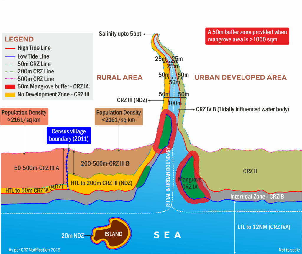
- CRZ is a zone that includes the coastal stretches of seas, bays, estuaries, creeks, and backwaters areas up to 500 meters from the High Tide Line (HTL).
- It also included the land between Low Tide line (LTL) and HTL as a Coastal Regulation Zone and imposed certain restrictions in the zone.
- It aimed to conserve and protect the environment of coastal stretches and marine areas, besides livelihood security to the fisher communities and other local communities.
- It excludes the islands of Andaman and Nicobar and Lakshadweep and the marine areas surrounding these islands, as Coastal Regulation Zone.
- CRZ-IA – Ecologically Sensitive Areas
- CRZ-IB – Intertidal Zone
- CRZ-II – Developed Land Areas (Municipal Limits / Urban Areas)
- CRZ-IIIA – Undeveloped rural areas with population density more than 2161/sq. km. and No Development Zone (NDZ) area up to 50 meters from the HTL on the landward side.
- CRZ-IIIB – Undeveloped rural areas with population density less than 2161/sq. km. and the area up to 200 meters from the HTL on the landward side as the NDZ.
- CRZ-IVA – The water area and the sea bed area between the Low Tide Line up to twelve nautical miles on the seaward side shall constitute CRZ-IV A
- CRZ-IVB – areas with water area and bed area between LTL at the bank of the tidal influenced water body to the LTL on the opposite side of the bank.
About Coastal Zone Management Plan (CZMP):
- It is also called the Island Coastal Regulation Zone Plan (ICRZP), issued under the Coastal Regulation Zone (CRZ) Notification, 1991.
- The coastal State Governments and Union territory (UT) administrations were entrusted with the preparation of CZMPs.
- This was through the agencies authorized by the Ministry of Environment, Forest and Climate Change (MoEFCC).
Steps for CZMP:
- Base Data: Utilize base data such as High Tide Line (HTL), Low Tide Line (LTL), Ecologically Sensitive Areas (ESAs), Hazard line, Critical Vulnerable Coastal Areas (CVCA), and existing CZMP database.
- Shapefiles from the CZMP database prepared as approved by the National Centre for Sustainable Coastal Management (NCSCM), as the base for revision or updation.
- Data Provided by States/UTs to Authorized Agencies: Village-wise survey numbers for government land, digitized geo-referenced Census village boundary maps, stakeholder data.
- CRZ Buffers: No Development Zone (NDZ)/Buffers for tidally influenced water bodies shall be 50 m for CRZ IIIA, 200 m for CRZ IIIB and 20 m for inland islands in coastal backwaters – 20 m.
- Processing of Census Data: Analyze 2011 census maps and data to compute population density for CRZ-III classification and classify based on population density (2161 per sq. km.)
- CRZ Classifications: Update CRZ classifications as per guidelines of CRZ Notification, 2019 and demarcate water areas of CRZ-IV and fishing zones.
- Municipal Limits: Categorize open spaces, parks, gardens in CRZ-II areas as No Development Zone.
- Public Consultation: Publish draft CZMP on state/UT websites for suggestions and objections.
- Technical Scrutiny Committee: Submit updated CZMP to Technical Scrutiny Committee for scrutiny and recommendations.
Ref: Source
| UPSC IAS Preparation Resources | |
| Current Affairs Analysis | Topperspedia |
| GS Shots | Simply Explained |
| Daily Flash Cards | Daily Quiz |


