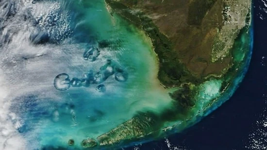
NASA’s Terra satellite recently captured images of Cavum Clouds above the Gulf of Mexico and off the coast of Florida.
About Cavum Clouds:
- Cavum clouds, often called hole-punch or fallstreak holes, are atmospheric phenomena characterized by large circular openings in clouds.
- An impressive example of cavum clouds was observed over the Gulf of Mexico near Florida’s west coast, captured by NASA’s Terra satellite.
- It was captured by the Moderate Resolution Imaging Spectroradiometer (MODIS) aboard the Terra satellite.
- These formations are caused by aircraft disrupting supercooled liquid water droplets within altocumulus clouds, leading to ice crystal formation and the creation of cloud holes.
- As aircraft move through altocumulus clouds, adiabatic expansion cools the surrounding air, further chilling supercooled droplets and prompting them to freeze.
- Altocumulus clouds are small, mid-level, white or gray clouds that are made up of a mix of water and ice.
- This process initiates ice crystal growth, leading to the formation of cavum clouds.
- The falling ice crystals create the wispy trails known as virga, visible at the center of the cloud holes.
- Virga resembles rain or snowfall and grows larger with time, but evaporates before reaching the surface.
- The shape and size of cavum clouds depend on factors such as the angle of aircraft intersection with the cloud layer, cloud thickness, air temperature, and wind shear.
- Different types of aircraft, from passenger jets to turboprops, can contribute to the formation of these cloud structures.
About Terra Satellite:
- Terra is the flagship satellite of Earth Observing System (EOS), initiated in 1982 by NASA.
- The EOS was established to acquire a long-term record of Earth observations and effects of natural and human-induced changes on the environment.
Five instruments aboard Terra:
- ASTER (Advanced Spaceborne Thermal Emission and Reflection Radiometer) provides high-resolution images of land, water, ice, and clouds.
- CERES (Clouds and the Earth’s Radiant Energy System) measures Earth’s radiation budget and atmospheric radiation.
- MISR (Multi-angle Imaging SpectroRadiometer) captures multidirectional observations to assess sunlight scattering, data on cloud properties, aerosol distribution, and land surface.
- MODIS (Moderate-Resolution Imaging Spectroradiometer) monitors atmospheric, oceanic, land surface, and cryospheric features, supporting research on climate change, vegetation dynamics, and oceanic processes.
- MOPITT (Measurements Of Pollution In The Troposphere) measures methane and carbon monoxide concentrations in the troposphere.
Ref:Source
| UPSC IAS Preparation Resources | |
| Current Affairs Analysis | Topperspedia |
| GS Shots | Simply Explained |
| Daily Flash Cards | Daily Quiz |


