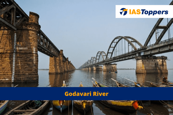
Godavari River or Dakshin Ganga is the largest river system in Peninsular India. The Godavari is the second largest basin in India, following the Ganges basin. In this article, you will get information about Godavari River system, Godavari River origin, tributaries, mineral resources, soil types, dams, projects on Godavari basin, providing key insights for GS Paper- I Indian Geography section of UPSC IAS Exam.
Table of Content
- Table of Content
- What is Godavari River?
- Godavari River Map with states:
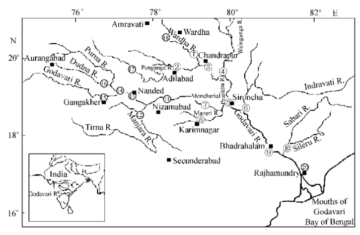
- Drainage of Godavari River
- Tributaries of Godavari River
- Left bank tributaries of Godavari River
- Right bank tributaries of Godavari River
- Segments of Godavari River Basin
- Mineral Resources in Godavari Basin
- Soil map of Godavari basin:
- Projects and dams on Godavari River
- Industries in Godavari Basin
- Floods and Droughts in Godavari Basin
- Amount of water in Godavari basin:
- Conclusion
- Frequently Asked Questions
- Reference
What is Godavari River?
- The Godavari River is the largest river system in Peninsular India.
- The Godavari River is also known as Dakshin Ganga.
- The Godavari originates from the Sahyadris near Trimbakeshwar in Nasik district of Maharashtra.
- The Godavari River’s length is 1,465 km anda catchment area of over 3.13 lakh sq. km.
- The Godavari is the second largest basin in India, following the Ganges basin.
- The Godavari River travels the Deccan Plateau from the Western Ghats to the Eastern Ghats.
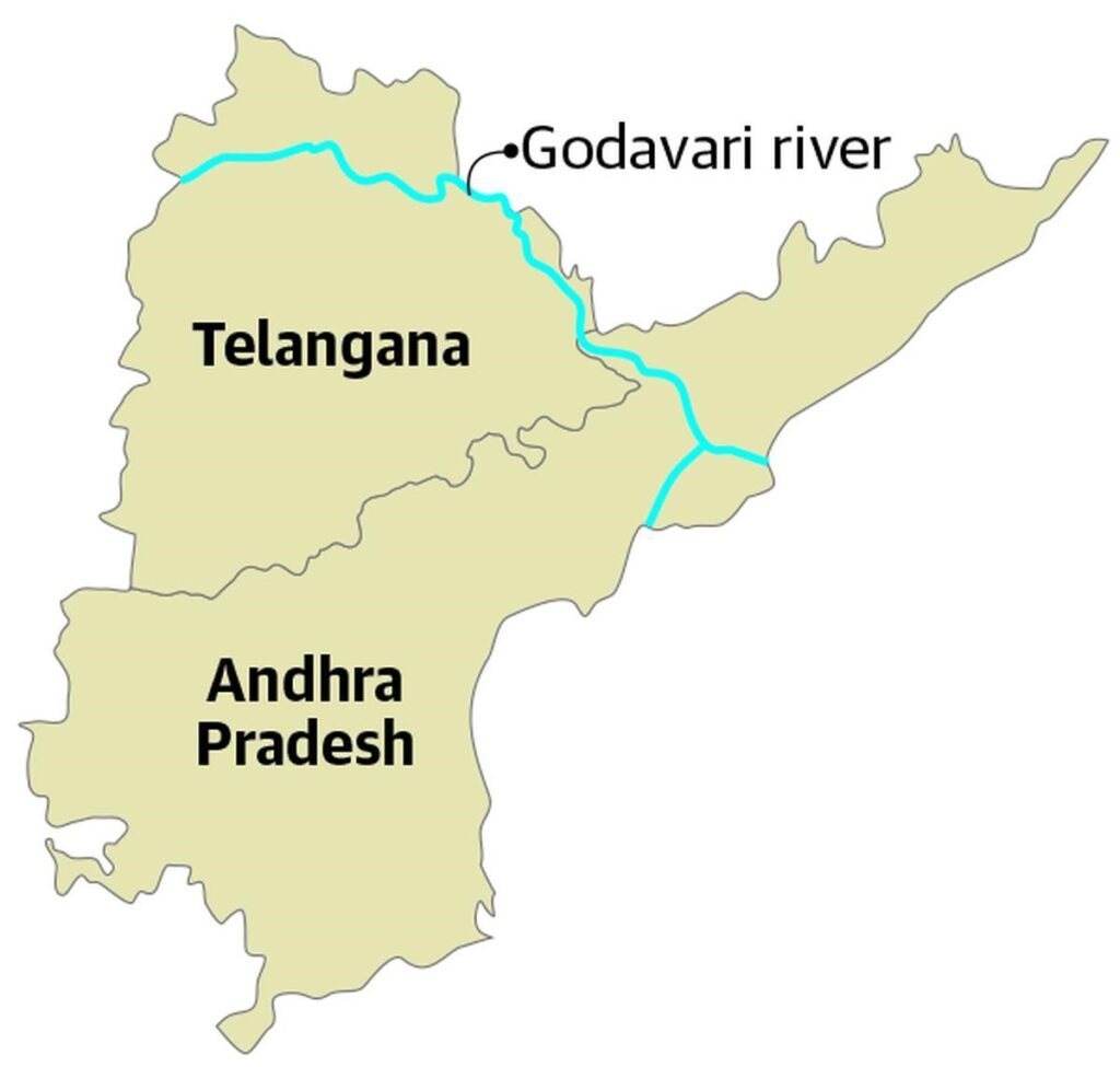
Godavari River Map with states:
Drainage of Godavari River
- The Godavari drains into the Bay of Bengal.
- The Godavari flows through the states of Maharashtra, Telangana, Andhra Pradesh, Chhattisgarh, Odisha, and smaller parts of Madhya Pradesh, Karnataka, and the Union Territory of Puducherry (Yanam).
- 49% of the Godavari lies in Maharashtra, 20% in Madhya Pradesh and Chhattisgarh, and the rest in Andhra Pradesh and other regions.
- The Godavari basin is surrounded by the Satmala hills, Ajanta range, Mahadeo hills, Eastern Ghats, and Western Ghats.
- Below Rajahmundry in Andhra Pradesh, the Godavari divides into the Gautami Godavari and Vashishta Godavari streams and forms a delta before reaching the Bay of Bengal.
- The Gautami branch joins the Bay of Bengal as it flows through the Yanam.
Tributaries of Godavari River
- The left bank tributaries include Dharna, Penganga, Purna, Wainganga, Wardha, Pranahita, Pench, Kanha, Sabari, and Indravati.
- The right bank tributaries include Pravara, Mula, Manjra, Peddavagu, and Maner.
Left bank tributaries of Godavari River
- The left bank tributaries of the Godavari are larger and more than the right bank tributaries.
- Pranahita is a combination of waters from Penganga, Wardha, and Wainganga.
Purna
- Origin: The Purna originates in the Ajanta Range of hills.
- The Purna flows in a southeast direction until it joins the Godavari near Purna town.
- The Purna drainage area lies entirely within Maharashtra.
- Tributaries of the Purna are Damna and Kailna on the north bank and Arjna, Girja, and Dudhana on the south bank.
Penganga
- The Penganga includes the entire catchment of the Penganga River from its source to its confluence with the Wardha river, along with all its tributaries.
- The Penganga serves as an inter-state sub-basin between Telangana and Maharashtra, forming the boundary between the two states.
- Tributaries of the Penganga are Kayadhu, Pus, Arunavati, Waghadi, and Khuni.
Wardha
- The Wardha sub-basin includes the Wardha river from its source to its confluence, along with all its tributaries, excluding the catchment of the Penganga.
- The Wardha serves as an inter-state sub–basin among Madhya Pradesh, Maharashtra, and Telangana.
- Before its confluence with the Wainganga, it forms the boundary between Maharashtra and Telangana.
- Tributaries of the Wardha are Bembla and Wunna.
Pranahita
- The Pranahita is the largest tributary of the Godavari.
- The Pranahita covers approx. 34% of its drainage basin.
- The Pranahita serves as an inter-state sub-basin among Madhya Pradesh, Chhattisgarh, Maharashtra, and Telangana.
- The main Pranahita river forms the boundary between Telangana and Maharashtra.
- The Pranahita carries the combined waters of the Penganga, Wardha, and Wainganga rivers after the confluence of Wardha and Wainganga.
- The Pranahita meets the Godavari River from its left bank below the Manjira confluence near Kaleshwaram temple.
- Tributaries of the Pranahita are Bagh, Wainganga, Bawanthadi, Pench, Kanhan, Chulband, Garvi, Andhari, Kobragarhi, Dina Nadhi, and Peddavagu.
Indravati:
- The Indravati is the second–largest tributary of the Godavari.
- Origin: The Indravati originates on the western slopes of the Eastern Ghats in Kalahandi district, Odisha.
- The Indravati flows through the central part of the Dandakaranya region and joins the Godavari at its confluence with Pranahita.
- The Indravati serves as an inter-state sub-basin amongOdisha, Chhattisgarh, and Maharashtra.
- Tributaries of the Indravati are Narangi, Boardhig, Kotri, Nibra, and Bandia on the right bank, and Nandiraj and Dantewara on the left bank.
Sabari
- The Sabari is the last tributary of the Godavari.
- Origin: Sabari originates in the Sinkaram hill range of the Eastern Ghats in Koraput district, Odisha.
- The Sabari joins the Godavari River in Andhra Pradesh near Rudramkota town.
- Tributaries of the Sabari are Machkund or Sileru, Potteru.
- The Sabari also receives some water from Indravati through a natural link called Joura Nalla.
Right bank tributaries of Godavari River
Pravara:
- Origin: The Pravara originates in the Western Ghats and flows eastward
- The Pravara joins the Godavari upstream of the Jaikwadi Dam.
- The Pravara’s entire drainage area is located in Maharashtra.
Manjira:
- The Manjira is the longest tributary of the Godavari and joins it after passing through the Nizam Sagar reservoir.
- The Manjira serves as an inter-state sub-basin among Maharashtra, Karnataka, and Telangana.
- Origin: The Manjira originates in the Balaghat Range of hills.
- Tributaries of the Manjira are Terna, Karanja, Haldi on the right side, and Lendi and Maner on the left side.
Maner:
- The Maner River joins the Godavari river upstream of the Annaram Barrage.
- Origin: The Maner originates in the Rajanna Sirisilla district of Telangana.
- The entire catchment of the Maner lies within the state of Telangana.
Segments of Godavari River Basin
Upper Godavari:
- The Upper Godavari comprises the stretch of the Godavari River from its source to its meeting point with the Manjira River.
- This section falls entirely within Maharashtra.
- The Upper Godavari excludes the catchment area of Pravara, Purna and Manjira but includes the catchment areas of other tributaries that join the Godavari in this region.
Middle Godavari:
- The Middle Godavari segment comprises the stretch of the Godavari River from its confluence with the Manjira to its confluence with the Pranahita.
- The Middle Godavari serves an inter-state sub–basin between Telangana and Maharashtra.
- The Middle Godavari excludes the catchment area of Maner and Pranahita but includes the catchment areas of other tributaries that join the Godavari in this region.
Lower Godavari:
- The Lower Godavari segment comprises the lower part of the Godavari River from its confluence with the Pranahita to the sea.
- The Lower Godavari excludes the catchment area of Indravati and Sabari but includes the catchment areas of other tributaries that join the Godavari in this region.
- The Lower Godavari is an inter-state sub-basin among Telangana, Maharashtra, Chhattisgarh, and Andhra Pradesh.
- In the Lower Godavari, the Godavari forms the boundary between Maharashtra and Telangana and between Telangana and Chhattisgarh.
- Tributaries of the Lower Godavari are Taliperu, Lakhnawarm, Peddvagu, and Kinnerasani.
Mineral Resources in Godavari Basin
- The Upper Godavari contain minerals like magnetite, epidote, biotite, zircon, and chlorite in the Deccan Traps.
- The Middle Godavari contain rocks such as phyllites, quartzites, amphiboles, and granites.
- The Lower Godavari contain sediments and rocks from the Gondwana group, including thick coal seams like the Singareni Coal Seam in Telangana.
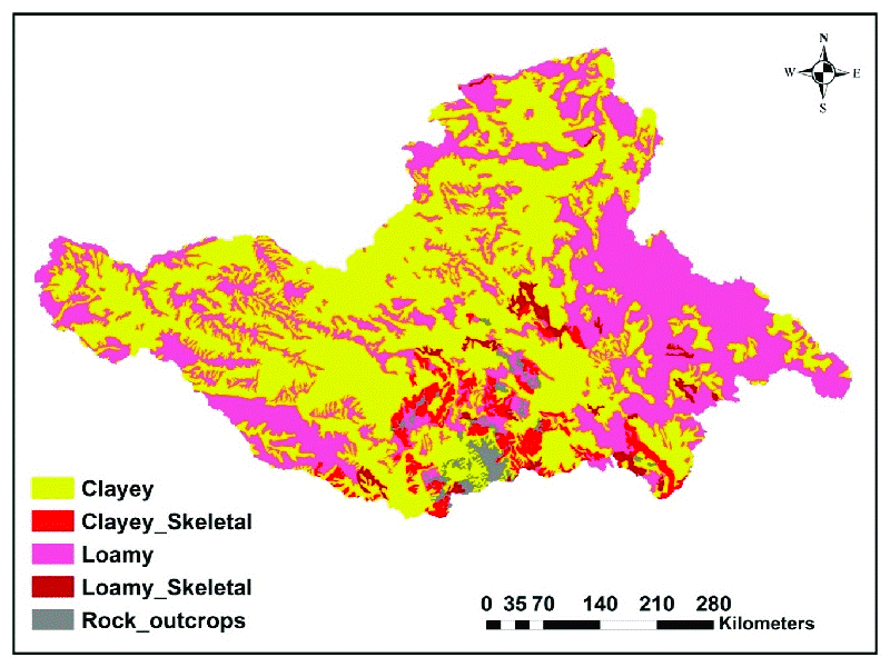
Soil map of Godavari basin:

Projects and dams on Godavari River
- Upper Godavari: Gangapur Dam, Darna Dam on the Darna River, Nandur-Madhameshwar Pickup Weir, Jaikwadi Dam, and Majalgaon Dam on the Sindhphana river.
- Middle Godavari: Pochampad Dam, Kadam Dam, Sripad Yellampalli Barrage, Sundilla Barrage, and Annaram Barrage.
- The last two barrages are part of the Kaleshwaram project.
- Lower Godavari: Medigadda Barrage and Pump House, Godavari LIS, Tupakulagudem Barrage, Sitaram LIS, Dummugudem Barrage, Polavaram Dam, Pattisema LIS, Pushkar LIS, Purushottapatnam LIS, Chintalpudi LIS, Chagalnadu LIS, Venkatanagaram LIS, and Arthur Cotton Barrage on the main Godavari.
- The tributaries have projects such as Laknawaram Dam, Taliperu Dam, Peddavagu Dam, and Kinnerasani Dam.
- Purna: Khadakpurna Dam, Yeldari Dam, Siddheshwar Dam, and Dudhana Dam.
- Penganga: Upper Penganga Dam, Upper Pus Dam, Lower Pus Dam, Arunavati Dam, Waghadi Dam, and Saikheda Dam.
- Wardha: Bembla Dam, Upper Wardha Dam, and Lower Wardha Dam.
- Pranahita: Upper Wainganga, Dhuti Weir, Thanwar Dam, Bawanthadi Dam, Bagh Dam, Totaladoh Dam, Itiadoh Dam, Lower Chulband Dam, and Gosikhurd Dam.
- Indravati: Upper Indravati Dam in Odisha.
- Sabari: Upper Kolab Dam, Jalaput Dam, Machkund Power House, Balimela Dam, Balimela Power House, Potteru Weir, Guntwada Weir, Upper Sileru Power House, Donkarayi Dam, and Lower Sileru Power House.
- Pravara: Bhandardara Dam, Nilvande Dam, and Mula Dam.
- Manjira: Manar, Lendi, and Terna Dams in Maharashtra, Karanja Dam in Karnataka, and Singur and Nizam Sagar Dams in Telangana.
- Maner: include Upper Maner, Middle Maner, and Lower Maner Dams.
Industries in Godavari Basin
- Major urban centres in the Godavari basin are Nagpur, Aurangabad, Nashik, and Rajahmundry.
- Nashik and Aurangabad have a significant presence of automobile industries.
- Industries in the Godavari basin includes agricultural products such as rice milling, cotton spinning and weaving, and sugar and oil extraction.
- The Godavari basin also includes cement and small engineering industries.
Floods and Droughts in Godavari Basin
- The Lower Godavari frequently experiences flooding issues.
- Coastal areas drained by Godavari Basin are prone to cyclones.
- Drainage congestion occurs in the delta regions due to the flat topography.
- Marathwada in Maharashtra lying in the Godavari basin is drought prone.
Amount of water in Godavari basin:
- The Godavari has the minimum quantity of water in May, and the maximum in July-August.
- After August, there is a sharp fall in water flow although the volume of flow in October and November is higher than between January to May.
Ref: Source-1
FAQs (Frequently Asked Questions)
Which are the states that the Godavari flows through?
The Godavari flows through the states of Maharashtra, Telangana, Andhra Pradesh, Chhattisgarh, Odisha, and smaller parts of Madhya Pradesh, Karnataka, and the Union Territory of Puducherry (Yanam).
From which state does Godavari River originates?
Godavari river originates from Maharashtra.
Which are Godavari River’s starting and ending points?
The Godavari originates from the Sahyadris near Trimbakeshwar in Nasik district of Maharashtra and ends at Bay of Bengal.
Conclusion
Significance of Godavari lies in the fact that Hindus of India celebrates Godavari Maha Pushkaram or Godavari Pushkaralu after every 12 years when Jupiter enters the zodiac sign of Leo. Godavari forms an important basin in southern India that helps to maintain the water supply in


