The Himalayas are the world’s largest mountain system situated in Asia, which create a natural barrier between the Tibetan Plateau to the north and the alluvial plains of the Indian subcontinent to the south. Effective management of the Himalayan ecosystem requires a multi-faceted approach that combines scientific waste management, community participation, regulatory measures, and educational initiatives. In this article, you will know about the geography, significance, challenges and solutions for the Himalayas. To explore more interesting UPSC Geography topics of GS Paper -1 like the Himalayas, check out other articles and IAS Notes of IASToppers.
Table of Content
- Introduction
- Geography of Himalayas
- Significance of the Himalayas
- Ecological challenges faced by Himalayas
- Impact of Urbanization and Climate Change
- Government Initiatives for protecting the Himalayan Region
- Conclusion
- FAQs
Introduction
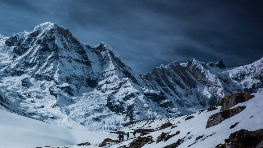
- The Himalayas, an awe-inspiring mountain system in Asia, create a natural barrier between the Tibetan Plateau to the north and the alluvial plains of the Indian subcontinent to the south.
- This majestic range is home to the world’s highest peaks, including more than 110 mountains exceeding 24,000 feet (7,300 meters) in elevation.
- The crown jewel of the Himalayas is Mount Everest which stands as the tallest peak on Earth at 29,032 feet (8,849 meters).
- For millennia, the Himalayas have held deep cultural and religious significance for the peoples of South Asia.
- The Sanskrit name “Himalaya,” meaning “abode of snow,” reflects the region’s profound impact on local literature, mythologies, and religions.
- The vast, glaciated heights of the Himalayas have long attracted pilgrims and mountaineers alike, offering both spiritual and physical challenges.
Geography of Himalayas
- The Himalayas- “a great wall between the Plateau of Tibet to the north and the alluvial plains of the Indian subcontinent to the south,” stretch in a concave arc from west to east.
- Geological History: Its formation is a result of the collision between the Indian subcontinental plate and the Eurasian Plate, which began around 40 to 50 million years ago.
- This monumental event led to subduction of the Indian Plate beneath the Tethys trench, creating the uplift that formed the Himalayas.
Physical Features and Extent
- It stretches about 2,500 km from west to east, spanning from Nanga Parbat (8,126 meters) in Pakistan to Namcha Barwa Peak (7,756 meters) in the Tibet Autonomous Region of China.
- The range varies in width from 200 to 400 km and covers an area of about 595,000 square km.
Countries and Regions
- India, Nepal, and Bhutan: Sovereignty over most of the Himalayas.
- Pakistan: Administers approximately 32,400 square miles (83,900 square km) in the Kashmir region.
- China: Controls about 14,000 square miles (36,000 square km) in the Ladakh region and claims territory in Arunachal Pradesh.
Major Longitudinal Belts
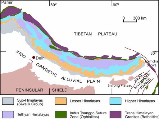
The Himalayas can be divided into four main longitudinal belts, each with unique physiographic features:
- Outer Himalayas (Siwalik Range): The southernmost range.
- Lesser Himalayas: Characterized by lower elevations and complex geological structures.
- Great Himalayas: The highest and most rugged part of the range.
- Tibetan Himalayas: Located in the north, including the Trans-Himalayas in Tibet.
Subregions:
- Kashmir Himalaya
- Himachal Pradesh Himalaya
- Kumaon Himalaya
- Central Himalayas
- Nepal Himalaya
- Assam Eastern Himalaya.
Key Geological Processes
- Formation of the Tethys Ocean: During the Jurassic Period (about 201 to 145 million years ago), the Tethys Ocean bordered the southern edge of Eurasia.
- Breakup of Gondwana: About 180 million years ago, the supercontinent Gondwana began to split, with the Indian subcontinental plate moving northward.
- Collision and Subduction: The Indian subcontinental plate collided with the Eurasian Plate, subducting beneath the Tethys trench and forming the Tibetan Plateau and Trans-Himalayan ranges.
- Mountain Building: Approximately 20 million years ago, intense uplift began, leading to the formation of the towering peaks of the Himalayas.
- Erosion and Deposition: Major rivers like the Indus, Ganges, and Brahmaputra have shaped the landscape by eroding material from the mountains and depositing it in the plains.
Biodiversity and Forest Types in the Himalayas
- The Himalayas are a significant biodiversity hotspot in South Asia, with 51% of the region’s biodiversity hotspots located here.
- The types of forests in the Himalayas are primarily determined by elevation and precipitation, with soils playing a lesser role.
- Low Elevations (up to 1000 m): Includes tropical moist deciduous and tropical dry deciduous forests. Dominant species- Shorea robusta in areas with higher rainfall.
- Subtropical Zone (1000–1800 m)
- Subtropical Broad-leaved Hill Forests: Dominated by species like Olea cuspidata and Shorea robusta.
- Subtropical Pine Forests: Dominated by Pinus roxburghii.
- Temperate Zone (1800–3600 m)
- Moist Temperate Forests: Dominated by Abies pindrow and Pinus wallichiana.
- Temperate Broad-leaved and Mixed Forests: Includes species like Quercus and Acer.
- Coniferous Forests: Dominated by Cedrus deodara, Picea smithiana, and Abies spp.
- Subalpine and Alpine Zones (above 3600 m)
- Subalpine Forests: Dominated by Tsuga dumosa and Rhododendron.
- Alpine Scrub Vegetation: Found at the highest elevations, transitioning to grasslands and sparse vegetation.
Significance of the Himalayas
- Climate Barrier: The Himalayas prevent the northward flow of moist monsoon winds, which results in heavy rainfall on their southern slopes and arid conditions on the northern side.
- Cultural and Spiritual: The Himalayas hold profound spiritual importance for Hinduism, Buddhism, and Jainism, symbolizing meditation, enlightenment, and self-discovery.
- The region is the birthplace of the Buddha, and is full of sacred natural sites such as secret valleys and high mountain lakes that predate ancient Hinduism.
- Biodiversity Hotspot: The region hosts a rich variety of plant and animal species, many of which are unique to the Himalayas.
- Water Source: Himalayan glaciers and snowfields are the source of major rivers- Ganges, Indus, Brahmaputra, and Yangtze, crucial for agriculture, hydropower, and water supply.
- Climate Regulation: The Himalayas influence monsoon patterns, providing vital rainfall to India, Nepal, and Bangladesh.
- Geological Importance: The Himalayas result from the collision between the Indian and Eurasian plates, influencing seismic activity.
- Highest Peaks: The Himalayas is the highest mountain range in the world, and has 9 out of 10 of the world’s highest peaks, including Mount Everest.
- These mountains, referred to as the Third Pole, are the source of some of Asia’s major rivers and also help to regulate our planet’s climate.
Ecological Challenges in the Himalayas
- Climate Change and Glacial Melting: Rising temperatures cause rapid glacial melting, affecting water availability for downstream communities.
- Accumulation of Black Carbon: Black carbon emissions accelerate glacier melting by increasing temperature and light absorption.
- Natural Disasters: The region is prone to landslides, avalanches, and earthquakes due to its young, rising mountains and tectonic activity.
- Soil Erosion and Landslides: Deforestation and improper land use increase soil erosion and landslide risks.
- Growth of Invasive Species: Rising temperatures allow invasive species to outcompete native flora and fauna, disrupting ecosystems.
- Flawed Development: Incidents like the landslide at Chamoli and the sinking of Joshimath in Uttarakhand highlight poor developmental practices.
- Massive projects like the Chardham Mahamarg Vikas Pariyojna lead to deforestation and soil erosion.
- Unregulated Tourism: Over 100 million tourists visited Uttarakhand in 2022, exceeding the region’s carrying capacity and stressing local resources.
- Rising Temperatures: The Himalayas are warming faster than other regions. The use of concrete in construction exacerbates the heat-island effect.
- Cultural Erosion: Urbanization disrupts traditional Himalayan lifestyles and erodes cultural knowledge and identity.
Impact of Urbanization and Climate Change
- Flawed Development: Infrastructure projects like the Chardham Mahamarg Vikas Pariyojna have led to deforestation and soil erosion, destabilizing the fragile Himalayan environment.
- Unregulated Tourism: The influx of millions of tourists strains local ecosystems and resources.
- Rising Temperatures: The Himalayas are warming faster than other regions, exacerbating glacier melt and affecting local climate patterns.
- Cultural Erosion: Urbanization disrupts traditional lifestyles and erodes cultural heritage.
- Solid Waste Accumulation: Increased tourism and urban expansion result in large quantities of solid waste being deposited in the region. This waste is often not properly managed, leading to environmental degradation.
- Untreated Sewage and Air Pollution: The absence of proper waste management systems results in untreated sewage entering water bodies, while construction activities and vehicle emissions contribute to air pollution.
- Unplanned Urban Growth: Rapid and unplanned urbanization, including construction activities without adherence to guidelines, is damaging the fragile ecosystem.
- Land Use for Tourism: Indiscriminate use of land for commercial tourist resorts disturbs the natural landscape and biodiversity.
Recommendations for Solid Waste Management
To mitigate these impacts, an integrated approach to environmental protection and economic development is necessary.
- Scientific Garbage Disposal Systems: Implementing systems like compost pits and organized waste collection can help manage solid waste effectively.
- Community Involvement: Engaging residents, schools, and businesses in waste management practices, as seen in the ‘Mission Butterfly’ project in Nainital, can ensure better environmental conservation and generate local employment.
- Awareness and Education: Programs aimed at increasing awareness about environmental issues, such as those conducted by the Lakes and Waterways Development Authority (LDA) in Srinagar, can drive community efforts towards conservation.
- Regulatory Measures: Enforcing regulations like the Assam Hill Land and Ecological Sites Act 2006 can prevent indiscriminate cutting of hills and filling of water bodies.
Government Initiatives to Protect the Himalayan Region
- National Mission on Sustaining Himalayan Ecosystem: Launched in 2010, this mission covers 11 states and 2 UTs under the National Action Plan on Climate Change.
- SECURE Himalaya Project: Part of the Global Wildlife Program, it promotes sustainable management of alpine pastures and forests.
- Mishra Committee Report 1976: Recommended restrictions on heavy construction and tree felling in the region to prevent land subsidence.
- NDMA Guidelines for GLOFs: Regulate tourism in Glacial Lake Outburst Floods-prone areas to reduce pollution.
- Trans-Boundary Collaboration: Create an international network for risk monitoring and early warning systems.
- Education and Awareness: Integrate knowledge of Himalayan geology and ecology into school curricula to foster environmental stewardship.
- Role of Local Governments: Update building bye-laws and focus on flood prevention and preparedness.
- Other Important Steps:
- Implement early warning systems and better weather forecasts.
- Promote sustainable and eco-friendly tourism.
- Conduct detailed project reports, environmental impact assessments, and social impact assessments before project implementation.
- Upgrade existing dams and prioritize regular monitoring.
Successful Conservation Initiatives
Nainital Lake Conservation Project
- The ‘Mission Butterfly’ initiative in Nainital demonstrates a successful model of participatory conservation and employment generation.
- The project involves regular waste collection from households, use of compost pits for waste management and Involvement of schools, hotels, and residents in maintaining the ecosystem.
Dal Lake Conservation Efforts
- Dal Lake in Jammu and Kashmir is a critical example of an ecosystem under stress due to human activity.
- Collaboration between different stakeholders promoted education and mass awareness about lake conservation, along with ban on polythene carry bags in the lake area reduced pollution.
Assam Hill Land and Ecological Sites Act 2006
- This act aims to prevent the cutting of hills and filling of water bodies in urban areas like Guwahati.
- This would bring ecological sites under state government protection to address ecological issues comprehensively.
Conclusion
The Himalayas are not only a formidable natural barrier and a vital ecological system but also a region of immense cultural and spiritual importance. Its protection requires a multifaceted approach involving sustainable development, community involvement, regulatory measures, and international cooperation. By addressing the ecological challenges and mitigating the impacts of urbanization, the IHR can preserve its unique ecological heritage while supporting sustainable development. Their dynamic geological history and ongoing natural processes continue to shape the landscape and life in the surrounding areas, making them a focal point for scientific research and adventure
FAQs(Frequently Asked Questions)
Where are the Himalayas?
The Himalayas stretch across land controlled by India, Nepal, Bhutan, Pakistan, and China.
How long are the Himalayas?
The Himalayas stretch uninterruptedly for about 1,550 miles (2,500 km) in Asia, forming a barrier between the Plateau of Tibet to the north and the alluvial plains of the Indian subcontinent to the south.
What are the physical features of the Himalayas?
The Himalayas include the highest mountains in the world, and are known for their soaring heights, steep-sided jagged peaks, valleys, and alpine glaciers, deep river gorges, and a series of elevational belts that display different ecological associations of flora, fauna, and climate. The mountains’ high peaks rise into the zone of perpetual snow.
Who drew the first known map of the Himalayas?
The first known Himalayan sketch map of some accuracy was drawn up in 1590 by Antonio Monserrate, a Spanish missionary to the court of the Mughal emperor Akbar.
What are the major rivers in the Himalayas?
The Himalayas are drained by 19 major rivers, of which the Indus and the Brahmaputra are the largest, each having catchment basins in the mountains of about 260,000 square km in extent.
When was highest peak in the Himalayas and the world, Mount Everest, first successfully scaled?
Mount Everest was first successfully scaled in May 1953 by the New Zealand mountaineer Edmund Hillary and his Tibetan partner Tenzing Norgay.


